Back جراند ريفر (نهر فى امريكا) ARZ Вялікая (рака, басейн возера Мічыган) Byelorussian Grand River (Michigan) Danish Grand River (Michigan) German Rivière Grande (Michigan) French Grand River (rivier yn Michigan) Frisian Grand River i Michigan NN Grand River (Michigan) NB Grand River (Michigan) Polish Grand (rijeka) Serbo-Croatian
This article needs additional citations for verification. (September 2009) |
| Grand River | |
|---|---|
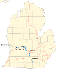
 A map of the Grand River | |
 | |
| Physical characteristics | |
| Source | |
| • location | Somerset Township, Hillsdale County, Michigan |
| • coordinates | 42°05′12″N 84°25′21″W / 42.08670°N 84.42245°W[1] |
| Mouth | |
• location | Grand Haven, Michigan |
• coordinates | 43°03′30″N 86°15′03″W / 43.05835°N 86.25088°W |
| Length | 252 miles (406 km) |
| Basin size | 5,572sq.mi. |
| Discharge | |
| • location | mouth |
| • average | 5,048.87 cu ft/s (142.968 m3/s) (estimate)[2] |
The Grand River (Ottawa: owashtanong, "Far-Flowing Water")[3][4] is a 252-mile-long (406 km) river in the Lower Peninsula of the U.S. state of Michigan. The longest river in Michigan,[5] the Grand River rises in Hillsdale County, and flows in a generally northwesterly direction to its mouth at Lake Michigan in the city of Grand Haven. The river flows through a number of cities, including Jackson, Lansing, Ionia, and Grand Rapids.
The river was famous for its mile-long, 300-yard-wide, and 10-to-15-foot-tall rapids, for which the city of Grand Rapids was named. These rapids were submerged following the construction of numerous dams, starting in 1835, and flooding of areas behind the dams. The river has not had any rapids for nearly a century.
- ^ "Grand River". Geographic Names Information System. United States Geological Survey, United States Department of the Interior.
- ^ United States Environmental Protection Agency. "Watershed Report: Grand River". watersgeo.epa.gov. Archived from the original on 2021-07-02. Retrieved 2021-07-02.
- ^ Richmond, Rebecca L. (1906). "The Fur Traders of the Grand River Valley". Publications of the Historical Society of Grand Rapids. 1. Grand Rapids, MI: Historical Society of Grand Rapids: 36. OCLC 13895154.
- ^ Siegel, Jane (1993). 'A Snug Little Place': Memories of Ada Michigan, 1821–1930. Ada, MI: Ada Historical Society. p. 18. OCLC 29485380.
- ^ "National Hydrography Dataset high-resolution flowline data". The National Map. U.S. Geological Survey. Archived from the original on March 29, 2012. Retrieved May 19, 2011.